Ms. Meller-Angus' Class Website
  • Home
  • US History (8th grade)
    • Review for the Government Test
    • THE WEST
    • The Men Who Built America
    • Industrial Revolution
    • BOOK CONTEST
    • Progressive Presidents >
      • Theodore Roosevelt
      • William Taft
      • Woodrow Wilson
  • Global Studies (9th Grade)
    • Media Literacy >
      • Basic Geography
      • Basic History
      • Current Korea
      • Nuclear war
      • Current News
    • Tools of Geography >
      • Map Scale
      • Latitude and Longitutde
      • Seasons & Map Projections
      • ZIka & Thematic Maps
      • Thematic Maps
    • Africa and Resource Managment >
      • Thematic Map
      • Overview of Conflicts
      • Blood Diamonds
      • Technology's Demand on Africa
    • Rwanda Genocide >
      • Geography
      • Hutu and Tutsi
      • Conflict
      • Hate Radio
      • Now
    • Asia >
      • History of China
      • China's Transformation
      • Current China
      • Population
      • Globalization & Economy
    • Afghanistan & Iraq Wars >
      • Afghanistan >
        • Brief History
        • 9/11
        • War
      • Iraq >
        • Brief HIstory
        • Operation Iraqi Freedom
      • ISIS
    • Monotheistic Religions >
      • Judaism
      • Christianity
      • Islam
  • American Sign Language
    • Unit 1: Introducing Oneself
    • Unit 2: Exchanging Personal Information
    • Unit 3: Talking about Surroundings
    • Unit 4: Telling Where You Live
    • Unit 5: Talking About Your Family
  • Social Studies
    • Unit 1-2: Getting Started
    • Unit 2: Before Columbus
    • Unit 3: The Settling of the Americas
    • Unit 4: Thirteen Colonies
    • Unit 5: Road to Revolution
    • Unit 6: Revolutionary War
    • Unit 7 Foundations of Government
    • Unit 8: Knowing Your Rights
    • Unit 9: The First Years of the United States
    • Chapter 10: Age of Jefferson and War of 1812
    • Chapter 11 & 12: The Making of Andrew Jackson's USA
    • Unit 13, 14, & 15 Causes of Civil War
    • Unit 16 Civil War
  • Project Lead the Way
  • Auto Desk Links
    • Autodesk Mini Projects
    • Pegboard Toy
    • Playground
    • Miniature Train

IRAQ-GEOGRAPHY

Picture
The climate in Iraq is mainly of the continental, subtropical semi-arid type, with the north and north-eastern mountainous regions having a Mediterranean climate. Rainfall is very seasonal and occurs in the winter from December to February.  Winters are cool to cold, with a day temperature of about 60F dropping at night 35.  Summers are dry and hot to extremely hot.
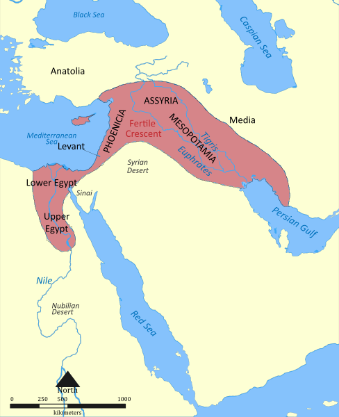
Iraq is located in the middle east and is roughly the size of Idaho.  6 countries border Iraq.  t has a very diverse region.   It is made up of desert, river valleys, highlands, and  plains.   It is the site between the Tigris and Euphrates Rivers, commonly referred to as the Fertile Crescent.  The Fertile Crescent is between the Tigris & Euphrates and was the bread basket of the middle east.  
Picture
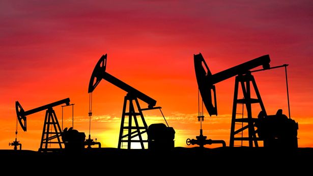
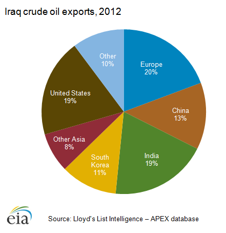
Iraq's natural resources are natural gas, sulfur, phosphates, and petroleum. Iraq has large reserves of petroleum and natural gas and the second largest oil reserves in the Middle East.    Iraq is a very industrious nation with many big cities.    
Picture
Picture
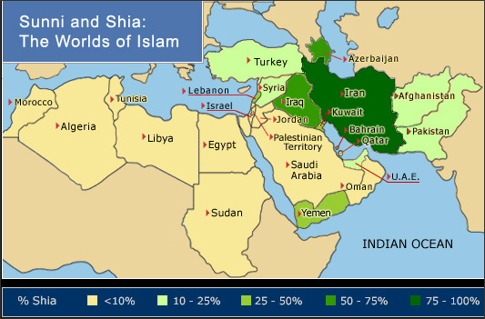
Islam is the main belief of Iraq.  Again the population is split between Shia and Sunni.  HOWEVER In Iraq however the Shia are in the majority and the Sunni are in the minority.  But, the people of Iraq  have been led by a minority leader (a Sunni) for many years.   This will lead to huge disagreements and conflicts within their society.                          Please look at map to right      -> -> -> 


To Brief History

Picture
Info from:  ftp://ftp.fao.org/docrep/fao/012/i0936e/i0936e08.pdf                           http://www.ask.com/question/iraq-s-natural-resources

Powered by Create your own unique website with customizable templates.