Ms. Meller-Angus' Class Website
  • Home
  • US History (8th grade)
    • Review for the Government Test
    • THE WEST
    • The Men Who Built America
    • Industrial Revolution
    • BOOK CONTEST
    • Progressive Presidents >
      • Theodore Roosevelt
      • William Taft
      • Woodrow Wilson
  • Global Studies (9th Grade)
    • Media Literacy >
      • Basic Geography
      • Basic History
      • Current Korea
      • Nuclear war
      • Current News
    • Tools of Geography >
      • Map Scale
      • Latitude and Longitutde
      • Seasons & Map Projections
      • ZIka & Thematic Maps
      • Thematic Maps
    • Africa and Resource Managment >
      • Thematic Map
      • Overview of Conflicts
      • Blood Diamonds
      • Technology's Demand on Africa
    • Rwanda Genocide >
      • Geography
      • Hutu and Tutsi
      • Conflict
      • Hate Radio
      • Now
    • Asia >
      • History of China
      • China's Transformation
      • Current China
      • Population
      • Globalization & Economy
    • Afghanistan & Iraq Wars >
      • Afghanistan >
        • Brief History
        • 9/11
        • War
      • Iraq >
        • Brief HIstory
        • Operation Iraqi Freedom
      • ISIS
    • Monotheistic Religions >
      • Judaism
      • Christianity
      • Islam
  • American Sign Language
    • Unit 1: Introducing Oneself
    • Unit 2: Exchanging Personal Information
    • Unit 3: Talking about Surroundings
    • Unit 4: Telling Where You Live
    • Unit 5: Talking About Your Family
  • Social Studies
    • Unit 1-2: Getting Started
    • Unit 2: Before Columbus
    • Unit 3: The Settling of the Americas
    • Unit 4: Thirteen Colonies
    • Unit 5: Road to Revolution
    • Unit 6: Revolutionary War
    • Unit 7 Foundations of Government
    • Unit 8: Knowing Your Rights
    • Unit 9: The First Years of the United States
    • Chapter 10: Age of Jefferson and War of 1812
    • Chapter 11 & 12: The Making of Andrew Jackson's USA
    • Unit 13, 14, & 15 Causes of Civil War
    • Unit 16 Civil War
  • Project Lead the Way
  • Auto Desk Links
    • Autodesk Mini Projects
    • Pegboard Toy
    • Playground
    • Miniature Train

Thematic Maps & Ebola 

docs.google.com/document/d/1-rj0nVSdCdsgGRsUGojy9wkh9Hln3HpgwrIFvyoL4f4/edit?usp=sharingThis  website has many different types of thematic maps.  A  thematic map is a type of map or chart especially designed to show a particular theme connected with a specific geographic area. These maps "can portray physical, social, political, cultural, economic, sociological, agricultural, or any other aspects of a city, state, region, nation, or continent".  

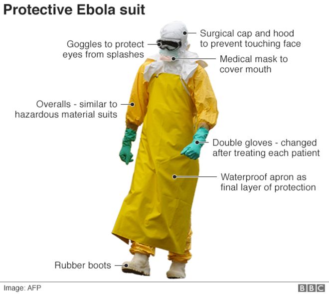
Your textbook discussed a deadly disease called cholera.  It spread through contaminated water during 1854.   John Snow (doctor)  was able to figure out the source by plotting out the cases of sickness.   (He made a thematic map!)  The same can be true of a very deadly disease that is spreading through Africa, Ebola. 
​
Please complete handout.

Step 1: Watch video on Below

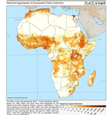
Step 2: Population Map of AFrica

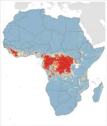
​Below is population density map of Africa.  Middle map is of past Ebola breakouts in Africa. Click on link to see bigger.  
Population
Picture
Past areas Ebola has been affected since 1960s
Picture
Political Map
Picture

Step 3

STEP 4

Picture
Picture

Step 6

Powered by Create your own unique website with customizable templates.