AFrica & REsource Management (Lesson below Focuses on success Criteria 1d & 2D)
You will need to have your political maps. If you do not have it with you, here is a link. You will be using those as you refer to the thematic maps on this page for location. In this activity you will use thematic maps to learn about the resources of Africa and connect this to the 7 Revolutions.
|
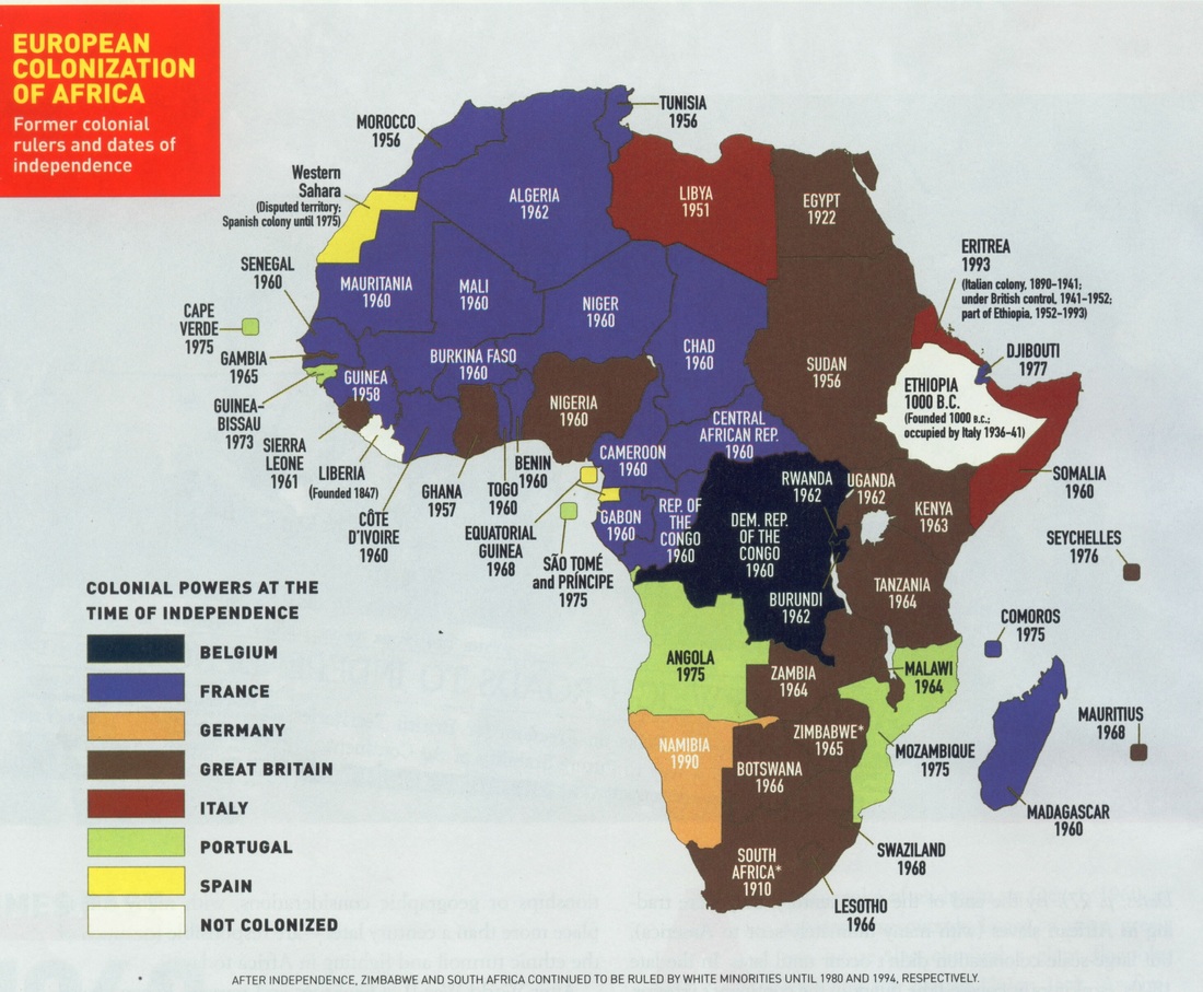
Please examine the map on the right and answer the questions below. Think back to the activity we did in class for question 2. European Colonization Link 1) What 3 European countries settle the most of Africa? Where do they settle? (A relative location is an acceptable answer) 2) When are most countries typically gaining their independence? 3 What issues can that cause? Why do you think those countries want them? |
|
distortion IN MAPS
Info below is from the Economist: www.economist.com/blogs/dailychart/2010/11/cartography
|
A sphere cannot be represented on a flat plane without distortion, which means all map projections distort in one way or another. Some projections show areas accurately but distort distances or scales, for example; others preserve the shapes of countries but misrepresent their areas. Gerardus Mercator's projection, published in 1569, was immediately useful because it depicts a line of constant bearing as a straight line, which is handy for marine navigation. The drawback is that it distorts the shapes and areas of large land masses, and the distortion gets progressively worse as you get closer to the poles. (Africa looks about the same size as Greenland under the Mercator projection, for example, even though it is in fact 14 times bigger.) This was not a big problem for 16th-century sailors, of course, and the Mercator projection remains popular to this day. In Mr Krause's map seems to have used the shapes of the countries from a Mercator projection, but has scaled up the outline of Africa, without changing its shape, to show the appropriate area. Questions 1) What is a positive to the Mercator Map? 2) What is a drawback to the Mercator Map? 3) As you look at Mr. Krause’s map of Africa what is one thing that surprises you? 4) As you look at Mr. Krause’s map of Africa what is one thing that DOES NOT surprise you? |
Mercador Projection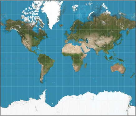
Mr. Krause MaP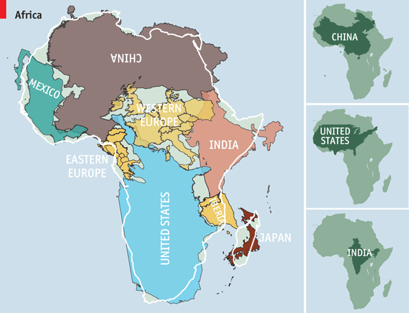
|
|
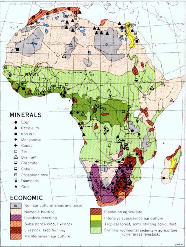
Economic Map
Please examine the economic map to the left. Economic Map Link 1) What resources does Africa seem to have the most of? 2) Where are diamonds located at? (Please write relative locations and then countries that are in that area.) 3) Where is the copper located? 4) Where is oil located? 5) Which country seems to have the greatest resources? What country had colonized it? Refer to map above. |
|
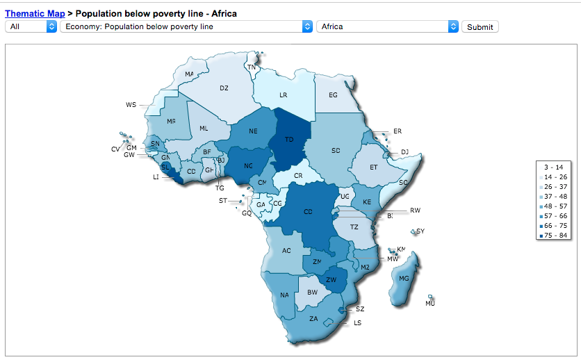
Poverty
Please use the map on the right. Africa poverty Map Link 1) What are three of the poorest countries? 2) Does it not have any resources? Why is it poor? (Compare with map above.) |
|
|
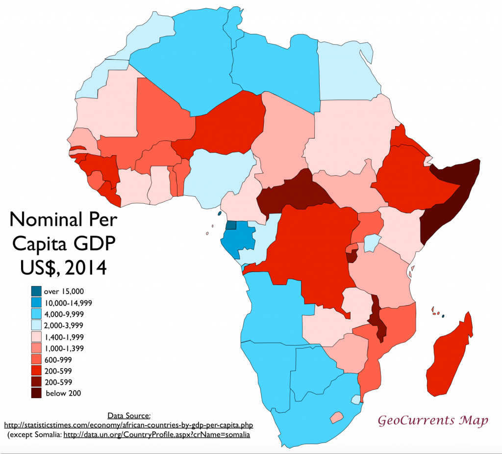
GDP
Please use the GDP per capita map. 1) Which three countries have the highest GDP? 2) Which three countries have the lowest GDP? 3) Are the three countries with the highest GDP also the countries with the lowest in poverty levels? 4) What resources are in these three countries? (Google to find out.) 5) How does this compare to the US GDP per capita? Is the high in Africa really that high? |
|
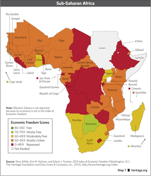
Economic Freedom
Economic freedom is the key to greater opportunity and an improved quality of life. It’s the freedom to choose how to produce, sell, and use your own resources, while respecting others’ rights to do the same. The Economic Freedom of the World Report, analyzes five subcomponents to measure a country’s level of economic freedom. These subcomponents include the size of government ; the legal structure and its protection of property rights; access to sound money; freedom to trade internationally; and regulation of credit, labor, and business. (Info from http://www.economicfreedom.org/) Economic Map Link Pick a country that would be considered least free based on the map to the right. Then go to http://www.heritage.org/index/ranking to help you and past maps from the website for the questions below. 1) What is the name of the country? What is the score? 2) What resources are there? 3) What is that country's GDP? 4) What are some other factors that would contribute to that score? Please explain. Pick a country that would be considered most free based on the map to the right. Then go to http://www.heritage.org/index/ranking to help you and past maps from the website for the questions below. 1) What is the name of the country? What is the score? 2) What resources are there? 3) What is that country's GDP? 4) What are some other factors that would contribute to that score? Please explain. |
|
|
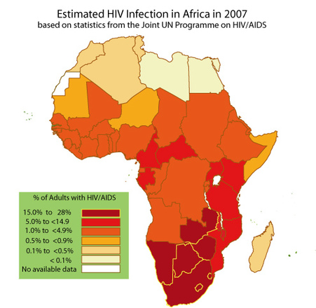
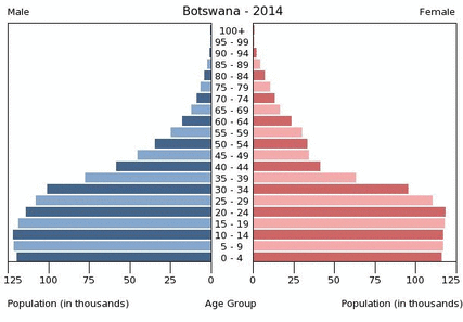
Disease/Population
Please you the map to the right for the first questions then the chart below. HIV MAP LINK & Botswana Population Pyramid
|
Something odd is happening in Botswana? What things are not adding up? What things seem surprising?
1) How is Botswana making money? 2) What are your predictions for AIDS here? Will AIDS decrease as income rises?
Overview of Conflicts
Overview of Conflicts
